


Voting District 150501, Dutchess County, New York
About
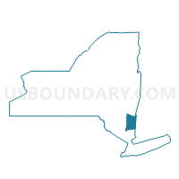
Outline

Summary
| Unique Area Identifier | 626389 |
| Name | Voting District 150501 |
| County | Dutchess County |
| State | New York |
| Area (square miles) | 2.16 |
| Land Area (square miles) | 1.76 |
| Water Area (square miles) | 0.40 |
| % of Land Area | 81.45 |
| % of Water Area | 18.55 |
| Latitude of the Internal Point | 41.66576020 |
| Longtitude of the Internal Point | -73.93659220 |
Maps


Graphs
Select a template below for downloading or customizing gragh for Voting District 150501, Dutchess County, New York


Neighbors
Neighoring Voting District (by Name) Neighboring Voting District on the Map
- Voting District 080004, Ulster County, NY
- Voting District 100003-100005, Ulster County, NY
- Voting District 150107 150503, Dutchess County, NY
- Voting District 150502, Dutchess County, NY
- Voting District 150504, Dutchess County, NY
- Voting District 150506, Dutchess County, NY
- Voting District 160201, Dutchess County, NY
- Voting District 160401, Dutchess County, NY
- Voting District 160402, Dutchess County, NY
- Voting District 160404, Dutchess County, NY
Top 10 Neighboring County Subdivision (by Population) Neighboring County Subdivision on the Map
- Poughkeepsie town, Dutchess County, NY (43,341)
- Poughkeepsie city, Dutchess County, NY (32,736)
- Lloyd town, Ulster County, NY (10,863)
- Marlborough town, Ulster County, NY (8,808)
Top 10 Neighboring Place (by Population) Neighboring Place on the Map
Top 10 Neighboring Unified School District (by Population) Neighboring Unified School District on the Map
- Poughkeepsie City School District, NY (32,602)
- Marlboro Central School District, NY (12,688)
- Highland Central School District, NY (12,514)
- Spackenkill Union Free School District, NY (8,870)
Top 10 Neighboring State Legislative District Lower Chamber (by Population) Neighboring State Legislative District Lower Chamber on the Map
Top 10 Neighboring State Legislative District Upper Chamber (by Population) Neighboring State Legislative District Upper Chamber on the Map
Top 10 Neighboring 111th Congressional District (by Population) Neighboring 111th Congressional District on the Map
Top 10 Neighboring Census Tract (by Population) Neighboring Census Tract on the Map
- Census Tract 1404, Dutchess County, NY (5,218)
- Census Tract 9537, Ulster County, NY (5,216)
- Census Tract 2208.01, Dutchess County, NY (4,077)
- Census Tract 9538, Ulster County, NY (3,946)
- Census Tract 2210.01, Dutchess County, NY (3,654)
- Census Tract 1406.02, Dutchess County, NY (2,840)
- Census Tract 1405, Dutchess County, NY (2,588)
- Census Tract 2207, Dutchess County, NY (2,517)